Drone technology is well established and being adapted for ag applications. Now, who will carry the message to the farmers? John Dobberstein, Associate Editor
In the not-so-distant future, farmers wanting to scout fields for diseases and pests, spot spray for weeds or obtain 3-D maps of their farmland will be turning to tiny autonomous helicopters or planes to do the job.
Armed with powerful cameras, these unmanned aerial vehicles (UAVs) — known in popular culture as “drones” — can cover hundreds of acres in an hour and provide a birds-eye view of fields down to canopy level.
Many see the emergence of UAVs or drones as the next major stage in the development and adoption of precision farming. This, of course, begs the question of who will take the lead in introducing the technology to farmers and servicing it as growers adopt the new equipment?
As farm equipment dealers know, selling the hardware is the easy part. Servicing drone technology once it’s in the field is another matter altogether.
“You’re going to see an evolution no different than what we’ve seen with crop sensors, where 2-3 years ago we weren’t seeing a lot of traction. It’s going to depend on who is educated on the technology, who knows it and who can put the components together,” says Steve Cubbage, president of Prime Meridian.
“You have a drone, but what sensors do you need on it? If you know that hardware and know the calibrations and how to put that package together, that’s where there’s opportunity for dealers,” he says.
Emerging Drone Market
After establishing a foothold in the military, agriculture is seen as one of the last frontiers for UAV use because of the increased use of precision technology in farm operations. The units are already being used in Canada, Europe, Asia and South America for various tasks.
The UAV market is mostly undeveloped in the U.S. due to strict FAA regulations, but some farmers are buying the units anyway or requesting demonstrations. The FAA in 2015 is expected to reveal a plan for integrating UAVs into airspace rules, but it’s unclear how long it would take to implement the guidelines.
Rory Paul — whose Chesterfield, Mo., company, Volt Aerial Robotics, makes and sells rotary-copter and small fixed-wing UAVs — believes the units are “personal farming implements” that can help farmers get more timely, accurate information about their crops and fields.
“We should have the right to operate these technologies over our properties, to the benefit of the ground below,” he says.
UAV Basics
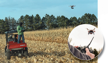
Typically, UAVs are small enough to fit into a small suitcase and are launched from the side of a field or area of interest. Guided by a radio controller, laptop computer or tablet, the device flies between pre-determined waypoints to film or photograph the desired field areas.
Cameras on the UAVs may take two-dimensional, high-definition photos where every pixel is linked to a GPS location on the ground. The UAVs can also transmit live video images from the flight to ground control.
Depending on the model, some cameras can take thermal images of plants in fields, or 3-D models that depict subtle changes in elevation can be built from these images using software.
The accuracy of UAV maps may range from 12 inches to only a quarter inch, depending on how many ground-control points there are. Going for sub-inch accuracy takes time and money, but it’s achievable, Paul says.
“As long as you have one ground-control point every quarter of a mile, you can get sub-meter accuracy,” Paul says. “Corrections are done post process.”
Rotary-wing UAVs can fly up to 20 minutes, depending on the payload. Fixed-wing units can fly about an hour. Ranges can differ depending on the controller, but most UAVs have a range of 2-4 miles.
The rule of thumb with operating UAVs in wind conditions is that bigger UAVs can withstand greater forces. Smaller rotary helicopters can be flown in winds gusting anywhere from 20-52 mph, while fixed-wing systems must fly into and out of the wind rather than across it to generate satisfactory images.
Some UAVs allow operators to upload new directions in flight so the unit can change missions or direction. And if the radio link is lost and not re-established — or the battery begins to go out — the device will fly back to the launch point.
Prices range from $500 for basic units currently found on the Internet to nearly $100,000, although Paul believes U.S. pricing will fall significantly in the coming years.
A major advantage of UAVs is they’re highly deployable. “If you need me tomorrow in Nebraska, I can pack the UAV into a suitcase and I’m heading out there to go on a flight,” he says.
Changing Farm Decisions
UAVs may indeed change the way farm decisions are made, especially when the technology and point of view provided by the units can be combined with ground truthing to document conditions in fields.
Drew Janes, who founded Jackson, Mo.-based Aerial Precision Ag, set up a booth at the 2013 Ag Connect Expo in Kansas City and sold out his inventory.
UAVs, such as Aerial Precision Ag’s multi-rotor unit were meant to help farmers with numerous field tasks, says Drew Janes, who founded the Jackson, Mo., company earlier this year. This could include scouting fields and pastures, looking for weed patches or even monitoring irrigation equipment. Photo Courtesy of Drew Janes
About a year ago, he built some of the drones for his company, Relentless Inc., to film farm operations for Case IH. Then he first brought a UAV to the 2012 Farm Progress Show and had dozens of farmers ask where they could get one.
Janes says APA has worked to create an easy-to-use UAV kit that can be deployed in less than 2 minutes from opening the machine’s carrying case.
“Farmers are searching for ways to make operations more efficient and practical because scouting crops and managing fertilizer, or water use, is a huge time-intensive task,” says Janes, who grew up working for his parents’ fertilizer chemical dealership in the Midwest. “Most of our interested customers are row-crop farmers, but at some shows you see livestock farmers who want them to check on cows or what’s happening in pastures, as well as feed and water needs.”
In Canada, where a regulatory framework is in place for UAV use, these units are already helping farmers gather valuable data, assess environmental conditions and maximize yields.
Aeryon Labs Inc. based in Waterloo, Ontario, sells the Scout, a quadcopter that is capable of taking daytime and near-infrared images and merging them into Normalized Difference Vegetation Index (NDVI) images that can ascertain plant health, soil and water conditions and biomass production.
Imagery taken during flights can also be imported into GIS databases, stitched together with special software and used to generate 3-D reconstructions of fields.
In theory, farmers using a UAV could monitor farm operations at the same time every day or week and make proactive decisions, says Cameron Waite, global sales manager for Aeryon Labs.
“From a crop perspective, farmers can monitor and make decision on the application of water, fertilizer and pesticides,” Waite told attendees at the 20th annual Southwest Agricultural Conference in Ontario. “If you’ve got a hailstorm coming, or one just came through, you could see how your land was affected.”
Monitoring Crop Health
NDVI images could be especially useful to help farmers see how healthy their crop is or catch issues with crop stress, water, nutrients or weeds that they might have missed with the naked eye, and avoid having to make decisions about inputs that aren’t necessary.
“You can do precise, targeted applications of pesticides, nutrients and fertilizer and keep your costs down,” Waite says.
Multispectral cameras let farmers identify crop health, perform risk mitigation and even identify soil health. In the future, hyperspectral cameras will let farmers identify specific vegetation types. If ragweed affecting corn has six spectrums of light, the light bounces back in the sky and is picked up by the camera.
At a vineyard in British Columbia, a grape farmer trying to get a better understanding of his conditions was having geographical challenges. He used the Scout to take 90 images in 8 minutes over 7.5 acres, and generated image resolutions of 1.6 centimeters per pixel.
“Satellites may give you 1 meter per pixel and airplanes may give you 30-50 centimeters per pixel,” Waite says. “A fixed-wing UAV gets you about 5 centimeters per pixel. But we can get around 1 centimeter to as low as 3 millimeters per pixel.”
Applications for UAVs
Crop consultants and farmers have already demonstrated the viability of utilizing drone technology in various farming applications. Here are some examples of how UAVs have been utilized so far.
Mapping Fields. Already, small fixed-wing UAVs launched to fly over fields are helping farmers and ag crop consultants in Ontario. Felix Weber, who founded Ag Business & Crop in Palmerston, Ontario, after more than 20 years of farming, is also a distributor for senseFly’s Swinglet CAM and eBee fixed-wing UAVs. Weber has a pilot’s license and has always been keen to what can be seen in a farmer’s field from above.
Weber feels fixed-wing UAVs work better for scouting and mapping larger farm areas. “The CAM shows me patterns, things that I don’t see from the ground, and gives it to me in a format where I can make maps and extract GPS coordinates to go to a specific point in field,” Weber says.
One type of map showed the different soil types and organic matter. It included an area where an old fencerow was located that, several years later, still showed higher levels of organic matter than surrounding farm ground.
A few years ago, Weber did drainage maps for a farmer who didn’t know where his tile lines were located. After a rainy period where there some good drainage activity was taking place, images taken by the CAM showed where the tiles were located because the crops around them were in better health.
“You could see exactly where the lines were,” he says.
Farms in 3-D. Another way UAVs could improve farmer decision making is through mapping fields with 3-D technology to provide detailed topographical images where soil changes might be present.
While the technology may not be there yet, UAV-produced 3-D maps could even help farmers fine tune hybrid selection for higher elevations with less water or lower elevations with more water and higher organic matter.
Weber believes 3-D maps could be an additional tool to help farmers decide where to apply lime or other nutrients. “When you only look at yield data, you’re seeing the removal rate,” he says. “That doesn’t mean there is no potential in the lower-yielding areas, it’s just that something is going on that is hurting yields. Could it be fixed?”
Cutting Herbicide Costs. In an advanced setup, it’s possible that farmers could use a combination of UAVs for spot weed control, saving time and money spent on herbicide applications.
In theory, Paul says the process would start with a small, inexpensive UAV that maps a field at high resolution with a multispectral camera.
After the images are geo-referenced and auto-rectified to provide an accurate representation of the field, the location of weed patches is relayed to a larger, helicopter-type UAV that spot-sprays the patches with herbicides.
“This isn’t going to replace crop spraying, but it could augment spraying on a spot-application basis,” Paul says.
Scouting Crops. Crop scouting could be the best and highest use for UAVs. For example, UAVs could be valuable in assessing crop populations early in the season before the growing foliage makes individual plants indistinguishable.
“You could choose a spot in the field and count how many plants are in a row. The multi-copter will go back to that same exact spot and take another count,” Paul says. “You can get population counts more quickly and you can do a lot more of them.
“Later in the season, when the plants are too tall to be able to see the field, you can still get a general overview of the field. If you spot a problem, you can drop it down and determine what’s going on, or take a still image and walk out and do ground truthing because you have the GPS location.”
“Another benefit is on farms with pivot irrigation,” says Janes of APA. “You may have a problem with stand 3 or a nozzle at stand 4 is blocked. You can go scope the problem without walking through a muddy field — and you can have the info in minutes.”
UAVs could be useful as well for farmers, consultants or crop-insurance agents for scouting for damage from weather events, harmful insects, diseases or chemical drift.
Reducing Input Costs. There’s plenty of potential for UAVs to help West Coast farmers growing high-value crops gather quality data and reduce input costs through the use of aerial imaging, says Bret Kugelmass, founder and CEO of Airphrame, a precision farming consulting group in Davis, Calif., that uses fixed-wing UAVs made in-house.
The company has worked with farmers who have done trials with variable-rate seeding for vegetables, helping them plant lower-cost seed on poorer soils and better hybrids on higher-performing soils.
“Understanding what seeds go where requires some input from the farmer,” Kugelmass says. “But we get high-resolution data points throughout the field that are far better resolution than with a soil-based measuring unit. We can get sub-meter resolution to see gradients of soils.”
Doing this work with corn hybrids would take even more input from a farmer, “but we can help them capture where everything is happening on the farm by GPS tagging everything,” Kugelmass says.
Another use for UAVs would be monitoring crop progress before harvest. Kugelmass says a lot of tomato farmers set up contracts with canneries and must meet production goals based on a schedule that isn’t based on the optimal use of land itself.
“There’s no great way to predict the growth of those plants because weather patterns change so quickly,” Kugelmass says. “Now with UAVs, we have a way to track plant growth with a high degree of accuracy and optimize harvest time. With all this data collected over many fields, you won’t have to leave product on the field and you can use land more effectively.
Finding Pathogens. In the future, UAVs could detect, monitor and forecast the spread of fungus-like organisms like Phytophthora or Fusarium that put crops at risk.
Since 2008, several researchers and students at Virginia Tech Univ. have been deploying UAVs for “aerobiological sampling” at the university’s 3,200 acre Kentland Farm near Blacksburg, Va. The fixed-wing UAVs are fitted with spore-sampling devices on their wings that open and close like a clamshell as they trap airborne particles traveling hundreds of feet above the farm.
Delivering the Technology
With a seemingly endless list of applications, many of which haven’t been dreamed up yet, the question becomes who will deliver the drone technology and to whom will it be delivered?
“It remains to be seen where we’re going to see the use and sales of unmanned systems technology,” says Gretchen West, executive vice president of the Assn. for Unmanned Vehicle Systems International (AUVSI). “I know crop insurance companies are really interested in the technology to better monitor crops.
“I believe crop consultants are going to be a big buyer of the technology,” says West. “They are already scouting fields and helping farmers on foot or using manned aircraft. Walking a field back and forth can take a whole day, whereas an unmanned aerial system can take an hour and the farmer will probably have better data. A lot of farmers, especially larger ones, are already outsourcing their survey and scout work, so this is a really good business model for crop consultants.”
Michael Helling, business development manager for Trimble Navigation’s agricultural division, see numerous ways that UAV products and technology will be distributed.
“One way we envision delivery of the products is through some type of contracting role, where dealers would take the technology and offer a service to farmers or even to a crop consultant,” says Helling. “The traditional precision technology dealer would have an opportunity to fill that role and we see a lot of our dealers today expanding into that service space.”
Helling views the UAV technology as an extension of what many farm equipment and precision farming dealers are already doing. “There’s the hardware side, and also the side of taking the data and doing something with it. The data piece is the buzz today. We see a lot of our dealers going this way, so adding drone technology could be an extension of these offerings and a potential revenue-generator.”
West points out that there is a wide range of systems and technologies that will be available for agriculture. “Dealers will probably start selling smaller systems.”
Part of the reason for this is the training won’t be as difficult, so it’s possible that a precision farming technician at a dealership could do the training, she says. But there a price point differences depending upon the size and sophistication of the unmanned aerial system.
“Historically a lot of our manufacturer members have worked in the defense market, and the cost of the systems used by the military are much higher,” West says. “For the agriculture market, and others, the manufacturers need to see the long term value of these products and reduce their price points.”
A Service-Based Business
West also adds that in the future dealers could lease these systems and operate them for farmers, rather than training them how to operate them, which gets back to the service aspect of the business.
“What we’re seeing in a lot of dealerships is a move toward more service-based operations. Integrating this piece of software with that piece of hardware and calibrating it properly,” Cubbage says. “Other than the fact that UAVs are way cooler, it’s not a lot different from setting up a precision ag display.”
Dealers will inevitably focus on selling the technology and backup services, rather than simply selling a drone to a farmer. “I don’t see this happening right off the bat, but it could be that a farmer wants a dealer to do a flight plan over his 2,000 acres on July 7. That’s a service that could be offered. I think this is where we’re heading,” Cubbage says.
Like with any new technology, successful dealers will be those who are able to back the drone with service and solutions.
“One of the big things that growers are going to be looking for in the future is a kind of the Best Buy ‘Geek Squad’ service,” says Cubbage. “Farmers are going search out the people and the organizations that can put the UAV system components together and make sure they do what the farmer wants done — and done well. An iron dealer has a lot of resources that may or may not be fully utilized. If they can get answers, they can have integrated solutions. For many years, dealers have used third party products to complement their portfolio and drones are another example of that.”
Supplier Training & Support is
Critical in Adopting UAV Technology
In much the same way that precision farming technology has been rolled out to growers, Steve Cubbage, president of Prime Meridian, says that delivering UAV technology will be a learning process for dealers. “The question is what will be available from an education standpoint for dealers?”
“With some of the smaller systems, there’s not a lot of training needed,” says Gretchen West, executive vice president of the Assn. for Unmanned Vehicle Systems International (AUVSI). “For the larger systems, like crop dusting helicopters that can be 6 feet long, those could take a considerable amount of training and those requirements are relatively unknown, because we don’t yet know what the FAA will require for operation of unmanned aircraft.”
Michael Helling, business development manager for Trimble Navigation’s agricultural division, adds, “There’s definitely going to be comprehensive training required, depending on what part of the world you are in. In the U.S., the requirements will likely be quite strict.”
But he adds that Trimble is already planning for a rigorous training program.
“We have an area close to our office in Colorado where we can do some demos and develop a training program. For dealers, it’s going to probably be a training session where they go to get certified, depending on where the regulations land.
“Hopefully, we’ll be able to train people locally, who can then train others. Possibly, everyone will have to come to a single location for group training. Today, we have similar programs for auto-pilot so that people doing installs in the field have the proper training to be able to support the product,” Helling says.
West urges dealers to not downplay the need for training when it comes to drone technology. “In our community, farmers are concerned about the safety of their systems and manufacturers are committed to making sure they are safe,” she says. Unmanned technologies won’t be allowed to fly, and thus, not sold until the safety features are perfected, so dealers will need to be committed to the training the operators before selling them.”